
Page 25 - index
P. 25
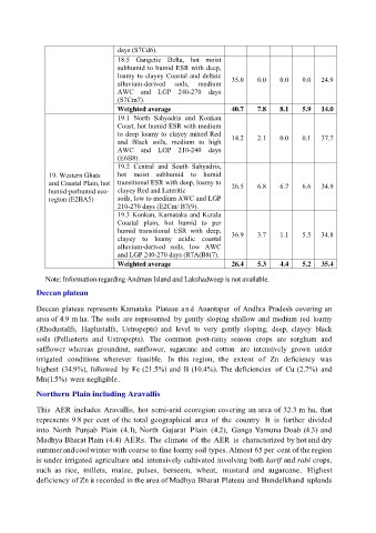
days (S7Cd6).
                                      18.5  Gangetic  Delta,  hot  moist
                                      subhumid to humid ESR with deep,
                                      loamy to clayey Coastal and deltaic   35.0   0.0    0.0    0.0   24.9
                                      alluvium-derived   soils,   medium
                                      AWC  and  LGP  240-270  days
                                      (S7Cm7).
                                      Weighted average                    40.7     7.8    8.1    5.9   14.0
                                      19.1  North  Sahyadris  and  Konkan
                                      Coast, hot humid ESR with medium
                                      to deep loamy to clayey mixed Red   14.2     2.1    0.0    0.1   37.7
                                      and  Black  soils,  medium  to  high
                                      AWC  and  LGP  210-240  days
                                      (E6B8).
                                      19.2  Central  and  South  Sahyadris,
                19. Western Ghats     hot  moist  subhumid  to  humid
                and Coastal Plain, hot  transitional ESR with deep, loamy to   26.5   6.8   6.7   6.6   34.9
                humid-perhumid eco-   clayey Red and Lateritic
                region (E2BA5)        soils, low to medium AWC and LGP
                                      210-270 days (E2Cm/ B7(9).
                                      19.3 Konkan, Karnataka and Kerala
                                      Coastal  plain,  hot  humid  to  per
                                      humid  transitional  ESR  with  deep,
                                      clayey  to  loamy  acidic  coastal   36.9    3.7    1.1    5.5   34.8
                                      alluvium-derived  soils,  low  AWC
                                      and LGP 240-270 days (R7A(B8(7).
                                      Weighted average                    26.4     5.3    4.4    5.2   35.4

               Note: Information regarding Andman Island and Lakshadweep is not available.

             Deccan plateau

             Deccan  plateau represents Karnataka  Plateau and Anantapur  of Andhra Pradesh covering an
             area of 4.9 m ha. The soils  are represented  by gently  sloping shallow  and medium red  loamy
             (Rhodustalfs,  Haplustalfs,  Ustropepts)  and  level  to  very  gently  sloping,  deep,  clayey  black
             soils  (Pellusterts  and  Ustropepts).  The  common  post-rainy  season  crops  are  sorghum  and
             safflower  whereas  groundnut,  sunflower,  sugarcane  and  cotton  are  intensively  grown  under
             irrigated  conditions  wherever  feasible.  In  this  region,  the  extent  of  Zn  deficiency  was
             highest  (34.9%), followed  by  Fe (21.5%) and  B (10.4%). The deficiencies  of  Cu (2.7%)  and
             Mn (1.5%) were negligible.

             Northern Plain including Aravallis

             This  AER  includes Aravallis,  hot  semi-arid ecoregion covering an area of 32.3 m ha, that
             represents 9.8 per cent of the total geographical area  of  the  country.  It  is  further  divided
             into  North  Punjab  Plain  (4.1), North  Gujarat  Plain  (4.2),  Ganga Yamuna Doab (4.3) and
             Madhya Bharat Plain (4.4) AERs. The climate  of  the AER  is  characterized by hot and dry
             summer and cool winter with coarse to fine loamy soil types. Almost 65 per cent of the region
             is under irrigated agriculture and  intensively cultivated involving both karif and rabi crops,
             such  as  rice,  millets,  maize,  pulses,  berseem,  wheat,  mustard  and  sugarcane.  Highest
             deficiency of Zn is recorded in the area of Madhya Bharat Plateau and Bundelkhand  uplands