
Page 18 - index
P. 18
Agro-ecological subregion wise mapping
Depending upon the soil, bioclimatic type and physiographic situations, the country
has been grouped into 20 agro-eco regions (AERs) and 60 agro-eco subregions
(AESRs). We have covered 58 AESRs for mapping micronutrient deficiency by
collecting and analyzing more than 2.00 lakh soil samples during 2011-2017 (Table 2.2
and Map 1 to 5).
Western Himalayas region
The Western Himalayas, AER is cold arid eco-region covering 15.2 mha area, which is
subdivided into AESR 1.1 (eastern aspect of Ladakh Plateau), and AESR 1.2 (western
aspect of Ladakh Plateau and north Kashmir Himalayas). The major soil type of the region
is skeletal and calcareous which can be further classified into Cryorthents and Cryorthids.
The major part of cultivated area is under vegetables followed by millets, wheat, fodder,
pulses and barley. The deficiency of Zn and Fe was generally absent, whereas 4.3, 4.4
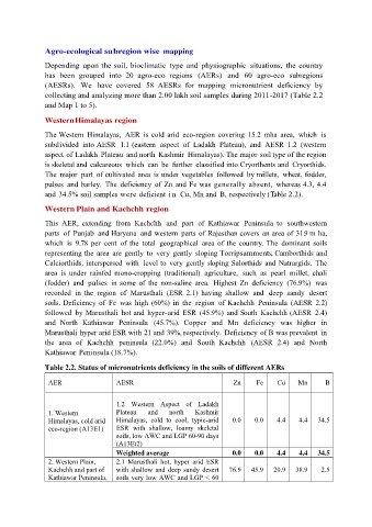
and 34.5% soil samples were deficient i n Cu, Mn and B, respectively (Table 2.2).
Western Plain and Kachchh region
This AER, extending from Kachchh and part of Kathiawar Peninsula to southwestern
parts of Punjab and Haryana and western parts of Rajasthan covers an area of 31.9 m ha,
which is 9.78 per cent of the total geographical area of the country. The dominant soils
representing the area are gently to very gently sloping Torripsamments , Camborthids and
Calciorthids, interspersed with level to very gently sloping Salorthids and Natrargids. The
area is under rainfed mono-cropping (traditional) agriculture, such as pearl millet, chali
(fodder) and pulses in some of the non-saline area. Highest Zn deficiency (76.9%) was
recorded in the region of Marusthali (ESR 2.1) having shallow and deep sandy desert
soils. Deficiency of Fe was high (60%) in the region of Kachchh Peninsula (AESR 2.2)
followed by Marusthali hot and hyper-arid ESR (45.9%) and South Kachchh (AESR 2.4)
and North Kathiawar Peninsula (45.7%). Copper and Mn deficiency was higher in
Marusthali hyper arid ESR with 21 and 39%, respectively. Deficiency of B was prevalent in
the area of Kachchh peninsula (22.0%) and South Kachchh (AESR 2.4) and North
Kathiawar Peninsula (18.7%).
Table 2.2. Status of micronutrients deficiency in the soils of different AERs
AER AESR Zn Fe Cu Mn B
1.2 Western Aspect of Ladakh
1. Western Plateau and north Kashmir
Himalayas, cold arid Himalayas, cold to cool, typic-arid 0.0 0.0 4.4 4.4 34.5
eco-region (A13E1) ESR with shallow, loamy skeletal
soils, low AWC and LGP 60-90 days
(A13Et2)
Weighted average 0.0 0.0 4.4 4.4 34.5
2. Western Plain, 2.1 Marusthali hot, hyper arid ESR
Kachchh and part of with shallow and deep sandy desert 76.9 45.9 20.9 38.9 2.5
Kathiawar Peninsula, soils very low AWC and LGP < 60